Showing posts with label Farms. Show all posts

Friday, 12 April 2019

Mitzpe Revivim

We stayed at Chai Negev on Kibbutz Revivim back in 2015 but at the time Mitzpe Revivim, the lookout where the pioneers of the kibbutz lived until 1950, was only open for group visits. I made a return visit with my dad a few months ago and this time, because we were with a group, we were able to look around the place. I don't really like visiting places with a group. I prefer to manage my own time and decide how long I need for the visit, but it was a good opportunity to see Mitzpe Revivim and I enjoyed our time there anyway.
Mitzpe Revivim was established in July 1943 as part of a plan to examine settlement prospects in the Negev. The founding group of settlers was given about 7000 acres of land, purchased in 1935 by the Keren Kayemet (Jewish National Fund). The settlement was initially named Tel HaTzofim (Scout's hill) and later renamed Revivim (rain showers). Its name is taken from the Bible, Psalm 65:11: "You (Lord) ... level its ridges, you soften it with showers." For seven years Revivim was the southernmost Jewish settlement in Israel.
The settlers faced many difficulties in the first years. They struggled against the heavy heat, aridity, lack of water and means of subsistence. A single-minded engineer named Dov Kublanov made many attempts to accumulate the water of the Revivim River, creating canals, a 1.2m dam and a cistern lined with tar. Unfortunately flood waters destroyed the canal walls, the reservoirs drained away into the ground and the system was abandoned. Eventually water was discovered at a depth of over 100m and a tractor was modified to pump it out. Recording rainfall, and experimenting in various ways, the settlers managed to find enough water to grow produce in the sand. They succeeded in transforming the research station into a kibbutz, a communal settlement, in 1948, following Israeli Independence.
During the Israeli War of Independence, Revivim fell behind Egyptian lines for several months. The siege was only lifted during Operation Horev at the end of December 1948. Members of the kibbutz lived in underground bunkers and food was supplied by air and land convoys. Thirty members of the kibbutz survived the war, while eight were killed in raids and pitched battles with Egyptian forces. Today you can view the trenches, bunkers and planes that brought arms and supplies to Revivim. 
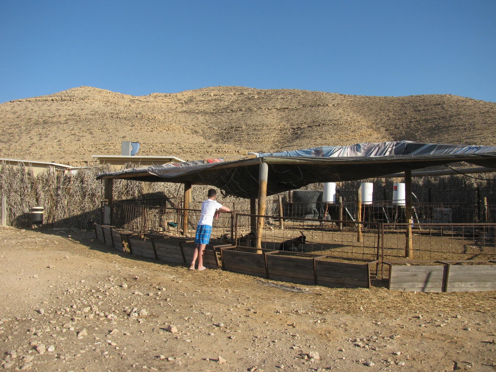
In the 1950s Revivim moved into new accommodation, very near to the original site. Fresh water arrived for the first time in 1955. Today the kibbutz thrives on a large olive crop, about 8000 acres of arable farming, as well as a dairy farm, a chicken hatchery, a fish growing farm and other non-agricultural industries. The old dwellings of the first settlers have been reconstructed and visitors can learn the story of this incredible community and its successful role in developing Jewish settlement and desert agriculture in the Negev, as well as the events of the 1948 war.
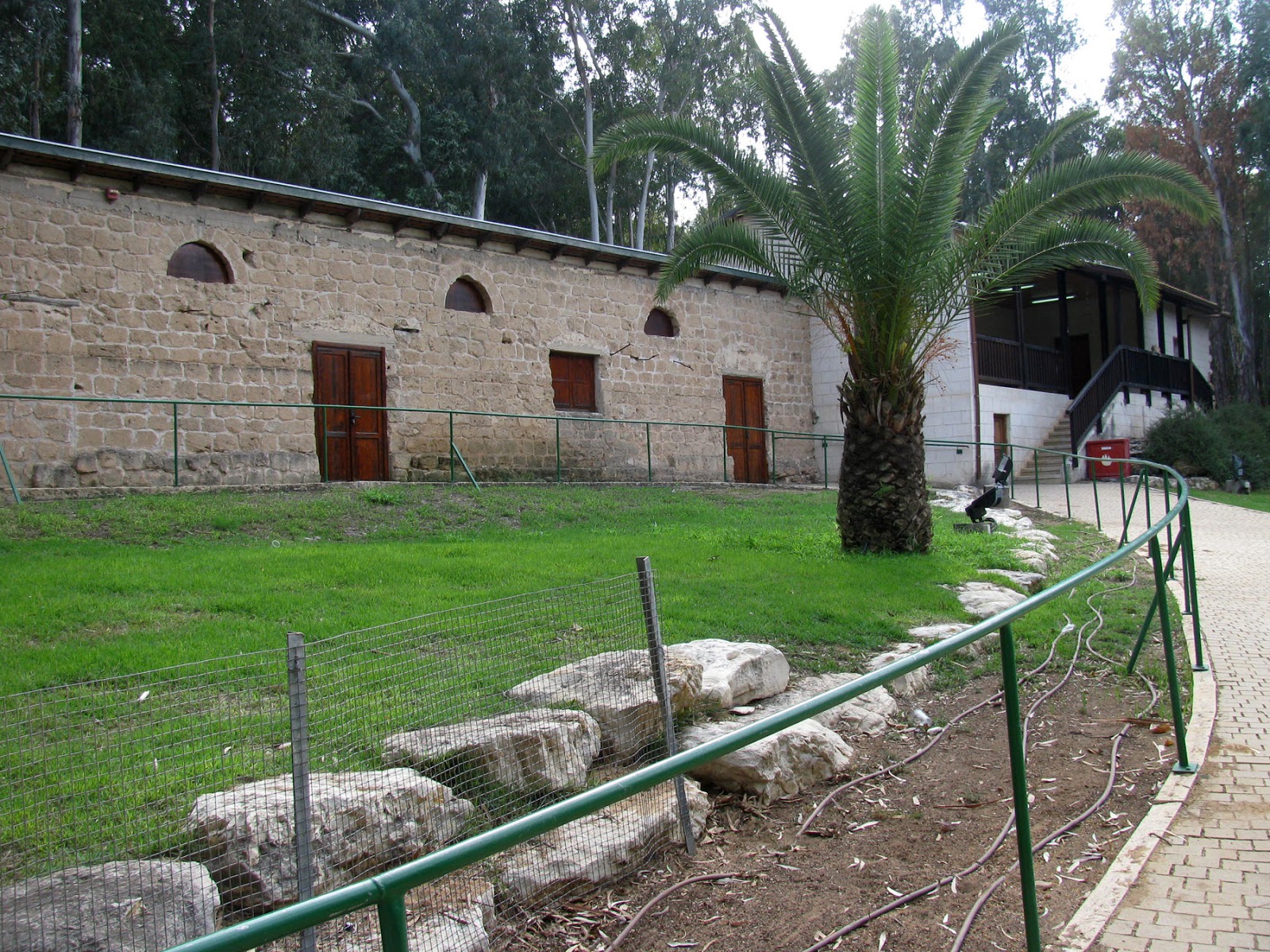
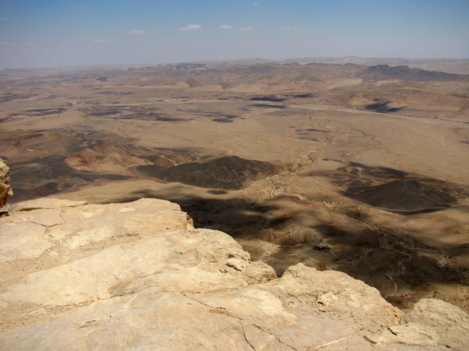
We saw how the settlers lived in the early days by exploring  the "castle" (all of the Negev mitzpim - lookouts -  were built like tiny castles and included a two-story security edifice within a courtyard surrounded by a wall made of stone), residential rooms, a radio room, a weapons room and the dining room. We looked at the tools and tractors used for agriculture, visited the aircraft compound and the dam room which tells the story of the settlers many attempts to accumulate water to irrigate the land with fresh water. The observation tower offered a wonderful view of the vast areas of Kibbutz Revivim, its fields and the large olive vineyard (bottom photo), as well as the bunkers and fortifications used through 1948. (Please make sure you click on the photo to appreciate just how incredible the view is).
There are two caves at Mitzpe Revivim which are actually water cisterns that were originally built by the Nabateans. The larger cave housed the settlers during their first year in Revivim and later became a field hospital. Pipes - which have become the symbol of the museum - were hastily erected as support when settlers needed to build a back wall in the cave.
The smaller cistern wasn’t discovered until 1948, when members dug the ground for a bomb shelter. This cistern became a command post during the War of Independence in 1948 and contains some vintage weapons and an escape hatch.
The establishment of Kibbutz Revivim and two similar outposts, Mitzpe Gvulot and Beit Eshel, helped sway the United Nations to include the Negev in the State of Israel. The Morrison-Grady plan, announced in July 1946, proposed dividing the country into three parts and leaving Jerusalem and the Negev out of Jewish hands, prohibiting settlement in the area. Instead, the area was to remain under British rule.
In 1943 Jewish leaders in Palestine sent little groups deep into the Negev, not only to conduct agricultural research, but also to gain a foothold on the land. In 1946, on the night of 5-6th October, the famous "Night Of The Eleven", eleven new settlements were formed overnight in order to assure a Jewish presence in the area prior to the partition of Palestine. None of the settlements were ever removed by the British and all but one of the settlements exist to this day (Kfar Darom was dismantled as part of Israeli disengagement from Gaza).

* This post has been shared on All SeasonsThe Good. The Random. The Fun.Wordless Wednesday (on Tuesday), Tuesday's TreasuresOur World Tuesday and My Corner of the World.
Sundays In My City

Tuesday, 12 February 2019

Hadera River Park

We had tried to visit the Hadera River Park (Park Nahal Hadera) on a previous occasion but unfortunately found it closed on a day when it should have been open. Unperturbed, we tried again when my dad was last here and this time we were successful! My dad was involved with the Jewish National Fund (JNF) in the UK for many, many years so I knew it was a JNF park that he was familiar with and one that he would like to see.
The park is built around the Hadera River which flows for some 50 kilometres through Israel's coastal plain before spilling into the sea to the north of Givat Olga, a neighbourhood in Hadera. Its main tributaries are the Haviva, Yitzhak, Hadera and Iron rivers. With time, extensive development in the surrounding area caused the river to become polluted by effluent flowing from factories and the local sewage plants, and until recent years, the area was a blot on the ecological landscape. However, after the Maor David Power Station (subsequently renamed Orot Yitzhak in memory of Israel's late Prime Minister Yitzhak Rabin) was built on the coast just north of where the river flows into the sea, a decision was taken to rehabilitate its western section. This once polluted meandering trickle has now been transformed into a fine straight river 40 metres wide, banked by a 1.3 km long promenade.
The JNF and the Israel Electric Corporation joined forces and established a development authority for the park. The rehabilitation work involved installing a pipe to channel the warm water beneath the power station on its way to the river. The power station pumps this water from the sea to cool its electricity production units. After use, the water is returned to the sea, about 10 degrees warmer than it had been originally, but otherwise no different from before; no pollution is involved.
Coal ash from the power station was used to construct a 17 metre high ramp on the river's north bank. After construction the ramp was covered with soil and coconut matting and planted with trees and shrubs to keep it stable, prevent erosion and integrate it into the landscape of the park. After stabilisation with stones and concrete, the south bank of the river has been transformed into the promenade. Its centrepiece is Fountain Square, where warm seawater bubbles up into a shallow pool. All along the riverbank fisherman can be observed casting their lines into the water and catching saltwater fish (mainly mullet).
The park includes two eucalyptus groves that were planted in the 1930s to prevent the sand dunes from spreading. Between these two areas, a prehistoric site from the Kebaran period (18,000 years ago) has been discovered. Flint tools were uncovered at the site, together with the bones of animals presumed to be gazelles and fallow deer. The park is also an excellent place to observe water birds such as the common kingfisher, the grey heron, moorhens, mallards and cormorants.
An interesting aside, the four chimneys of the power station are obviously high up but the hot water channelled below attracts about 30-40 grey sharks, mainly female, that stay from November-December to March every year.
As we were leaving the Hadera River Park we noticed a white domed structure in the distance and went to take a closer look. A sign there told us the most amazing story.
"Avshalom Feinberg was born in Gedera in 1889 to his parents Israel (Lulik) and Fanny (nee Belkind), who were founders of Hadera.
He was educated in Palestine and France and was a poet and a man of letters.
In World War I he initiated the establishment of the NILI espionage group. Under the leadership of Aharon Aharonsohn, it aimed to help the British oust the Turkish regime from Palestine.
He was murdered on 20 January 1917, on his way to contact the British command in Egypt.
Fifty years later in 1967, Major Shlomo Ben-Elkana of the IDF found his remains in the Sinai Desert. He was buried in a state funeral in Mount Herzl's military cemetery in Jerusalem.
This memorial, which was planned by architect Benjamin Orell, was built by Avshalom's sisters in 1957. It was originally situated on route no. 4 in Hadera, and transferred to this park in 2011."
Further reading told me that Avshalom Feinberg was one of the leaders of NILI, a Jewish spy network in Ottoman Palestine, helping the British fight the Ottoman Empire during World War I. He was born in Gedera, Palestine, then part of the Ottoman Empire, and studied in France. He returned to work with Aharon Aharonsohn at the agronomy research station in Atlit. Soon after the beginning of war, the four Aharonsohn siblings (Sarah Aaronsohn, Rivka, Alex, and Aharon) founded the NILI underground along with Feinberg. They were later joined by Yosef Lishansky and others. In 1915 Feinberg travelled to Egypt and made contact with British Naval Intelligence. In 1917, Feinberg again journeyed to Egypt, on foot. He was apparently killed on his way back by a group of Bedouins near the British front in Sinai, close to Rafah. His fate was unknown until after the 1967 Six-Day War when his remains were found under a palm tree that had grown from date seeds in his pocket to mark the spot where he lay.
In 1979 a new Israeli settlement in the Sinai Peninsula, Avshalom, was named after him. Although it was abandoned in 1982 following the Camp David Accords, a new village by the same name was founded in Israel in 1990. In addition, among the many and varied trees on the Mount Herzl military cemetery is one lone palm tree, replanted form its original spot in the Sinai Desert. This is the famous "Palm of Avshalom" under which Avshalom Feinberg's remains were found.
Hefziba Farm was just a short drive from the Hadera River Park. The farm was established on the banks of the Hadera River in 1906 in an area purchased by Yehoshua Hankin. His wife, Olga Hankin, named the site Hefziba, inspired by Isaiah's prophecy: "Nevermore shall you be called 'Forsaken,' nor shall your land be called 'Desolate;' But you shall be called 'I delight in her [Hefziba]" (Isa. 62:4), in the hope that the farm would not be abandoned and would thrive. The founding members of Kibbutz Hefziba, and other pioneers, lived first on the premises of the farm. Citrus fruit was grown there until World War I.
The Israel Electric Corporation purchased the 350 dunam (88 acre) plot in 1992 and restoration work is currently underway, together with the help of the National Council for the Preservation of Buildings and Historic Sites and the Hadera municipality. The farm is being reconstructed to house a historical park that will be a tribute to the early settlement of Israel.
The agricultural site, which now adjoins the busy Haifa-Tel Aviv motorway, was a symbol of efforts to make the desert bloom 100 years ago. It was established in the heart of sand dunes, on the northern coastal plain, among remnants of a forest that once contained Tabor oaks, ancient carobs, fruit orchards and eucalyptus groves. Some of the original buildings from 1906 are still standing, including  the farm manager's home and the old pump house on the riverbank. Beit Hahava (the farmhouse), above, has a sloping tile roof and a large veranda. It was used as the farm's office and as a dining room for the workers. The right wing of the structure was built in European style, while the left wing was built in local Arab style. Beit Hahava now serves as a visitor's centre.
The farm's heyday was in 1912, when it was expanded in response to border conflicts with Arab residents. Eight structures were built that year to house 60 workers who maintained the farm. Natural disasters, an attack of locusts and the ravages of World War I caused the site to be dismantled and finally abandoned in 1929.
The restoration project will be completed in stages over several years, and its tourism facilities are still being developed. A museum featuring the history of the farm and its surroundings is planned.
From the Hefziba Farm, you can walk along the banks of the Hadera River in a westerly direction. Stone markers have recently been placed along the path that goes under a bridge on the motorway. The path leads to a dam, which prevents the polluted waters of the river from reaching the sea. From the dam, you can continue back to the Hadera River Park, where we started our day.

* This post has been shared on Wordless Wednesday (on Tuesday)Pictorial Tuesday, Our World Tuesday, Tuesday's Treasures, The Keeping It Real Link Up, Travel Tuesday, Tuesdays with a Twist, Nature Notes, My Corner of the WorldWordless Wednesday Blog HopLittle Things ThursdayWeekend ReflectionsAll Seasons and Through My Lens.
Oregon Girl Around the World
Sunday Snap

Sunday, 30 September 2018

Mamshit National Park

The 2018 Perseids meteor shower, which is considered to be the best meteor shower of the year, peaked overnight on 12-13th August. The shower has peak rates of over 100 meteors per hour and, since it occurs in the warm summer months, is a popular summer star gazing activity. Together with a group of friends we decided to head down to Mamshit, a national park and world heritage site in the eastern section of the Negev desert, to watch the shower and camp in the grounds of the national park.
The night was beautifully clear and dark, and because we were camping in the desert, the skies were not polluted by any light. We didn't see quite as many meteors as I had expected - and certainly not 100 meteors per hour - but the the show picked up and we sometimes saw several every few seconds. Most were short, bright bursts of light. It was a wonderful experience.

We arrived at the campsite just before dusk so we only really had time to set up our tent and get the barbeque going before it got dark. Therefore it was a pleasant surprise the following morning to crawl out of my tent and find myself right next to the wonderful remains of a Nabatean city from Roman and Byzantine times!
Mamshit National Park was awarded the status of world heritage site by UNESCO in 2005, joining the other ancient desert cities of Avdat, Halutsa and Shivta - all on the Incense Route. Mamshit was the easternmost Nabatean city in the Negev and is the smallest, but it is also the best restored, with architectural elements featured that are unknown in other Nabatean cities.
The Nabateans were a nomadic people from the Arabian Peninsula and were experts on surviving in the desert. They entered the spice trade in the area during the fourth century BCE, but Mamshit was only built in the first century BCE when they stopped being nomads. The city was a trade post, but was also based on agriculture.
In 63 BCE the Nabatean desert cities were conquered by the Romans. Under Roman occupation the residents of the city began to raise and breed horses. They bred the Arabian horse and the city became wealthy. The Nabateans were also known for their stone cutting and high quality homes which lasted for hundreds of years, and were experts in collecting water in the desert, building cisterns and dams.
In the 4th century, the Byzantines took over the city and the residents converted to Christianity. They built churches and a 900m long wall for reinforcement. The wall encompassed the entire settlement, and Mamshit became the only fortified city in the Negev.
The name Mamshit comes from the Roman name for the place - Mampsis - while the Arab name for the city - Kurnub - is apparently Nabatean.
Visitors to Mamshit can see restored streets as well as Nabatean complexes that feature rooms, courtyards and terraces made of stone and supported by strong arches. There is a city reservoir and, alongside the reservoir, a bathhouse with three main sections: the frigidarium - cold room, tepidarium - warm room, and caldarium - hot room. The pottery pipes built in the walls, through which there was a flow of hot air, can still be seen. Additional things to see include the market place with shops on both sides, and the Wealthy House which was a huge villa with stables with space for 16 horses and a manger. The House of Frescoes has frescoes with paintings from Greek mythology of Cupid and Psyche. Some 10,500 silver coins from the 3rd century were found inside the house.
There are two impressive churches at Mamshit, one featuring a stunning mosaic floor with colourful geometric patterns, birds, a fruit basket, and five dedications in Greek; the other, remnants of a pulpit. The ruins of two large complexes outside the city walls provided accommodation for the merchants' caravans.
The ancient fortress of Mamshit was built at the highest point in the city. In 1936, the British Mandate forces built a police station for its desert mounted police force, which supervised the movements of Bedouins and Jews in the Negev. It was built on an ancient Nabatean structure. From the roof of the building there is an excellent view of the remains of ancient Mamshit and Mamshit Stream.
The city gate at Mamshit was built in the late Roman period. It was part of the city's fortifications, and was protected by two watchtowers. The gate and towers are marked on the Madaba map (a mosaic map from the 6th century CE, found in a church in the town of Madaba, Jordan).
In the 7th century, following Muslim conquest, the city declined until the point at which it was completely abandoned. Before the founding of the State of Israel, Prime Minister to-be David Ben-Gurion saw Mamshit as the capital of the future country, which dovetailed with his dream of settling the Negev desert.
After a good couple of hours exploring Mamshit's restored streets, rooms, courtyards and stone terraces it was time to move on. I love the idea of camping but I don't sleep well in a tent. We had made a reservation for a cabin for the following two days at Naot Farm, a family-run farm producing goat cheese in the Negev, just a few minutes' drive from Sde Boker, the home of David Ben Gurion. I was looking forward to a dip in the plunge pool and a comfortable bed! En route (well actually it was kind of off route!) we made a stop at Mitspe Ramon, above.
Mitspe Ramon is a town in the Negev whose name Ramon comes from the Hebrew "Roma'im" meaning Romans. The town overlooks a sizable erosion crater or makhtesh known as the Ramon Crater. A landform unique to Israel's Negev and Egypt's Sinai deserts', a makhtesh is a large erosion cirque, created 220 million years ago when oceans covered the area. The Ramon Crater measures 40km in length and between 2 and 10km in width, and forms Israel's largest national park. Though we have visited it many times before, the views are always breathtaking and a stop there never gets boring.
Then we arrived at Naot Farm, our peaceful desert lodgings. Naot Farm was established in 2004 and was the fulfillment of a dream for the owners, Lea and Gadi Nahimov. After making the decision to move to the Negev, the couple started working with goats and making cheese at the Har HaRuach goat farm near Jerusalem, one of our favourite haunts. They then started with 50 young goats at their own farm, which is situated in an enclave surrounded by bare hills, and in time they got acquainted with the desert. They discovered the delights of the desert including spiny mice and rock partridges, wolves and hyenas, spectacular floods, blossom after rain, the sky's Milky Way, and the quiet - mostly the quiet.
In July 2004 the Nahimovs opened their dairy farm, along with a small shop to sell their produce. Within a year the first two guest cabins were established, which increased over time to five.
We loved our cabin, with its delightful veranda, desert views and of course the hammock and plunge pool. Breakfast was brought to us in a cool box and included fresh goat cheese, salads, and different dips, along with eggs, fresh bread, and cold orange juice.
We found plenty to do in the area, which I will tell you about in another post, but there was also time to relax and to discover the beauty and serenity of the desert. Naot Farm is a fantastic place to stay if you are looking for a different experience in the Negev. We will definitely return.