The night was beautifully clear and dark, and because we were camping in the desert, the skies were not polluted by any light. We didn't see quite as many meteors as I had expected - and certainly not 100 meteors per hour - but the the show picked up and we sometimes saw several every few seconds. Most were short, bright bursts of light. It was a wonderful experience.


We arrived at the campsite just before dusk so we only really had time to set up our tent and get the barbeque going before it got dark. Therefore it was a pleasant surprise the following morning to crawl out of my tent and find myself right next to the wonderful remains of a Nabatean city from Roman and Byzantine times!
Mamshit National Park was awarded the status of world heritage site by UNESCO in 2005, joining the other ancient desert cities of Avdat, Halutsa and Shivta - all on the Incense Route. Mamshit was the easternmost Nabatean city in the Negev and is the smallest, but it is also the best restored, with architectural elements featured that are unknown in other Nabatean cities.
In 63 BCE the Nabatean desert cities were conquered by the Romans. Under Roman occupation the residents of the city began to raise and breed horses. They bred the Arabian horse and the city became wealthy. The Nabateans were also known for their stone cutting and high quality homes which lasted for hundreds of years, and were experts in collecting water in the desert, building cisterns and dams.
In the 4th century, the Byzantines took over the city and the residents converted to Christianity. They built churches and a 900m long wall for reinforcement. The wall encompassed the entire settlement, and Mamshit became the only fortified city in the Negev.
The name Mamshit comes from the Roman name for the place - Mampsis - while the Arab name for the city - Kurnub - is apparently Nabatean.


There are two impressive churches at Mamshit, one featuring a stunning mosaic floor with colourful geometric patterns, birds, a fruit basket, and five dedications in Greek; the other, remnants of a pulpit. The ruins of two large complexes outside the city walls provided accommodation for the merchants' caravans.
The ancient fortress of Mamshit was built at the highest point in the city. In 1936, the British Mandate forces built a police station for its desert mounted police force, which supervised the movements of Bedouins and Jews in the Negev. It was built on an ancient Nabatean structure. From the roof of the building there is an excellent view of the remains of ancient Mamshit and Mamshit Stream.


 The city gate at Mamshit was built in the late Roman period. It was part of the city's fortifications, and was protected by two watchtowers. The gate and towers are marked on the Madaba map (a mosaic map from the 6th century CE, found in a church in the town of Madaba, Jordan).


 After a good couple of hours exploring Mamshit's restored streets, rooms, courtyards and stone terraces it was time to move on. I love the idea of camping but I don't sleep well in a tent. We had made a reservation for a cabin for the following two days at Naot Farm, a family-run farm producing goat cheese in the Negev, just a few minutes' drive from Sde Boker, the home of David Ben Gurion. I was looking forward to a dip in the plunge pool and a comfortable bed! En route (well actually it was kind of off route!) we made a stop at Mitspe Ramon, above.


In the 7th century, following Muslim conquest, the city declined until the point at which it was completely abandoned. Before the founding of the State of Israel, Prime Minister to-be David Ben-Gurion saw Mamshit as the capital of the future country, which dovetailed with his dream of settling the Negev desert.
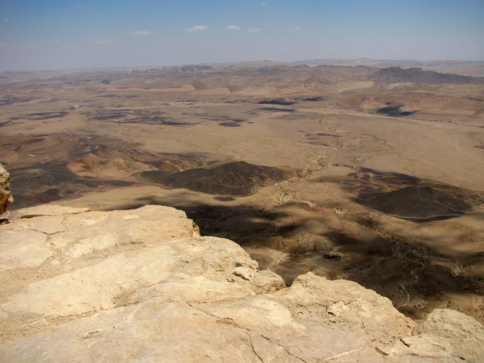


Mitspe Ramon is a town in the Negev whose name Ramon comes from the Hebrew "Roma'im" meaning Romans. The town overlooks a sizable erosion crater or makhtesh known as the Ramon Crater. A landform unique to Israel's Negev and Egypt's Sinai deserts', a makhtesh is a large erosion cirque, created 220 million years ago when oceans covered the area. The Ramon Crater measures 40km in length and between 2 and 10km in width, and forms Israel's largest national park. Though we have visited it many times before, the views are always breathtaking and a stop there never gets boring.


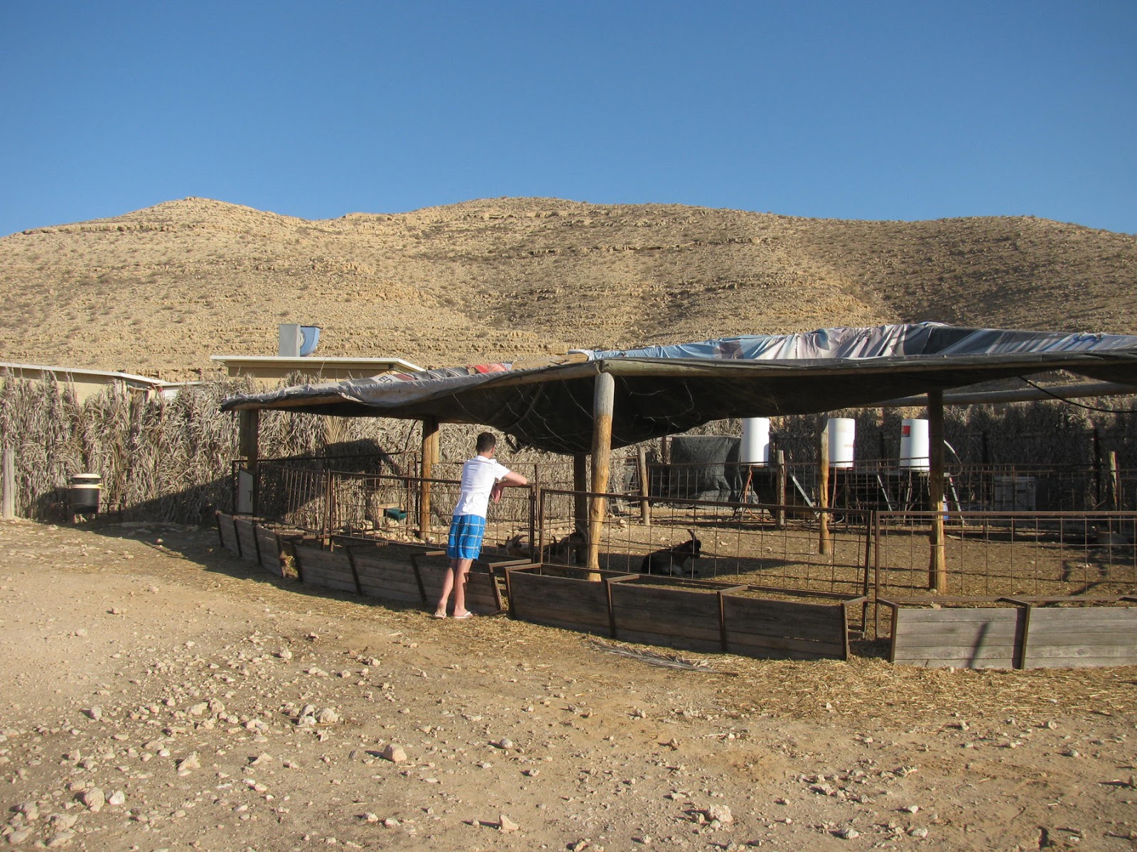
Then we arrived at Naot Farm, our peaceful desert lodgings. Naot Farm was established in 2004 and was the fulfillment of a dream for the owners, Lea and Gadi Nahimov. After making the decision to move to the Negev, the couple started working with goats and making cheese at the Har HaRuach goat farm near Jerusalem, one of our favourite haunts. They then started with 50 young goats at their own farm, which is situated in an enclave surrounded by bare hills, and in time they got acquainted with the desert. They discovered the delights of the desert including spiny mice and rock partridges, wolves and hyenas, spectacular floods, blossom after rain, the sky's Milky Way, and the quiet - mostly the quiet.
In July 2004 the Nahimovs opened their dairy farm, along with a small shop to sell their produce. Within a year the first two guest cabins were established, which increased over time to five.
We loved our cabin, with its delightful veranda, desert views and of course the hammock and plunge pool. Breakfast was brought to us in a cool box and included fresh goat cheese, salads, and different dips, along with eggs, fresh bread, and cold orange juice.
We found plenty to do in the area, which I will tell you about in another post, but there was also time to relax and to discover the beauty and serenity of the desert. Naot Farm is a fantastic place to stay if you are looking for a different experience in the Negev. We will definitely return.


* This post has been shared on All Seasons, The Good. The Random. The Fun., Wordless Wednesday (on Tuesday), Pictorial Tuesday and The Keeping It Real Link Up.