Showing posts with label National Parks. Show all posts

Thursday, 27 January 2022

Mrar Hills National Park

The Mrar Hills are situated in the Shfela (Judaean foothills), south of the city of Rehovot and north of Gedera. The hills are the fourth and last ridge among the kurkar (calcareous sandstone) ridges on the southern coastal plain. Open kurkar areas in Israel are in decline and their rich world of flora and fauna, some of which are unique to them, are disappearing. Part of the kurkar ridge in the southern part of the Mrar Hills has been declared a national park and is maintained by the Nature and Parks Authority. 
The Mrar hills rise 94 meters above sea level. In the Book of Joshua they are defined as a mountain, "Mount Baalah", on the border of the lands of Dan and Judah. Potsherds from the Chalcolithic period and burial caves from the Middle Bronze Age and the Roman and Byzantine periods, above, have been found in the hills, showing that people have lived in Mrar for many generations. 
Some of the caves may have been turned into dwellings or storerooms during the Ottoman period, when there was a Muslim cave village here. The name Mrar ("caves" in Arabic) shows us the importance of caves to the village.
At the end of the Ottoman period - and to this day - orchards were planted in the fertile soil that collected in the valleys between the kurkar ridges. The inhabitants of Mrar Hills had a few water sources, the most important and dependable of which was the Sorek Stream, which flows from the south. During the Ottoman period the village had a well and a cistern. The village also had a controlling view of its surroundings, which gave it a strategic advantage, an important element in pre-modern times for the development of a settlement. On the west was the ancient international road connecting Egypt and Syria (the "Via Maris" or "Way of the Sea"). Another road linked the settlements that developed to the east. In certain periods an east-west road passed south of the village, connecting the coastal plain with the Judaean lowlands and the Jerusalem Mountains.
At the top of the hill are water storage pools built by the Mekorot company as part of the Yarkon-Negev water line that was established between 1952 and 1955, before construction of the National Water Carrier. Their purpose was to channel water from the Yarkon Springs to agricultural communities in the northern Negev.
A statue of a horseman stands nearby as a reminder of the many battles that have taken place in these hills, before the establishment of the State of Israel. On 13th November 1917, as part of the battles of the First World War in Israel, the Battle of the Mrar Hills took place on the ridge. British forces launched a combined assault, when English cavalry (Yeomanry) and Scottish infantry fought against 3,000 Ottoman troops and defeated them. The British forces on their way to Ramle encountered the Ottoman forces occupying positions in the ridge and nearby villages. At the end of the battle, the British took control of the main railway junction, with railway lines leading to the south of Israel, and opened the way to the Jerusalem-Jaffa road. The retreating Ottoman forces lost hundreds of troops and about a thousand were captured by the British. The British lost about 500 soldiers.
The Yeomanry charge at these hills, known as El Mughar Ridge, is considered one of the last cavalry charges in military history.
The agave shrub can be found in several locations on the hills, above. Agave grows for about 10 years before it blooms, which it only does once in its lifetime. Before the agave blooms, it produces a long, thick trunk from which a cluster of thousands of fragrant yellow flowers emerges, which are pollinated by birds. Arabs customarily plant the agave in cemeteries. Agave was once grown in Israel to produce fibre and medication, but today it is used for ornamental purposes only. Other species of agave elsewhere in the world are cultivated to make sugar and tequila.
On the southeastern fringe of the ridge lay an Arab village called Al-Ma'ar ("The caves"), from which the name of the hills full of kurkar caves was derived. With the construction of RAF Aqir, which served as the main Royal Air Force station in Palestine during the Second World War, the importance of the village increased. At the beginning of the War of Independence, in May 1948, the village was captured by the IDF. After the war, the newly named Tel Nof Airbase became a central base for training the Paratroopers Brigade. A monument to the fallen paratroopers in Israel's wars, which we saw at the start of our visit, is located at Tel Nof, near a site that was once a major paratroopers base.
In 2020, the The Mrar Hills National Park was upgraded. Stairs were built, paths were paved and signs were set up explaining the landscape, the vegetation and the battle of the cavalry that took place there. The metal horseman found his place high up on the ridge.
From the top of the hill there is a spectacular view of the surrounding settlements: to the southwest you can see Gedera, to the southeast is Moshav Beit Elazari, established in 1948 by Jewish immigrants from eastern Europe. You can also see the runway and hangars of the Tel Nof Air Force Base.
Before returning to our car parked at the paratroopers monument, we stopped for a rest on the grass in front of the monument, above. The towering pillar of the monument, with parachute wings, is carved with the words of the poet and Special Operations Executive, Hannah Szenes, "A voice called to me - and I went, I went because the voice called." The monument's long stone wall is inscribed with the biblical verse: "They were swifter than eagles, they were stronger than lions." (2 Samuel 1:23). On the wall the names of the paratroopers who fell from 1949 onward. The monument was built at the initiative of the paratroopers force and the bereaved families. It was unveiled on 29th October 1960.

PoCoLo

Monday, 15 November 2021

Twenty One

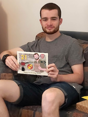
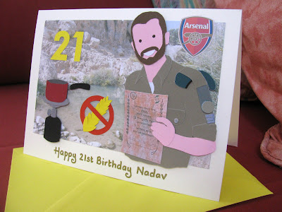
My eldest son turned 21! Birthdays in our home always come with a handmade card made by mum and it doesn't seem that long ago that the pinky purple Bleeper People, from his favourite pop-up book as a small child Where, Oh Where, is Kipper's Bear?, appeared on his birthday card. Now he's in his third year of service in the Israel Defence Forces (IDF) and the themes I picked for his special card were slightly different!
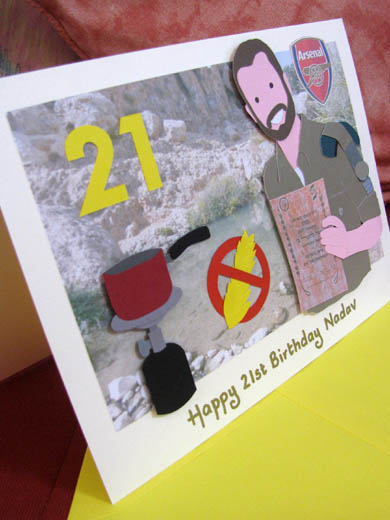
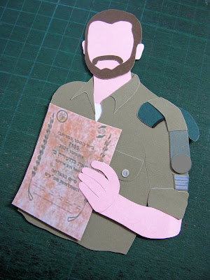
This year I have shown my eldest son in his olive green army uniform, holding a certificate he recently received for a course he just completed. When he is home from the army he likes to go on tiyulim (hikes) with his friends. They recently went to Ein Prat, the biggest of three springs along the Prat Stream (Wadi Qelt), a stream that flows along the northern Judean desert, from Jerusalem to Jericho and then to the Jordan River. I have shown the spring in the background and added his pakal kafe (coffee kit), which he often takes with him. The word "pakal" is actually an acronym of the words "pkudat keva lechayal," which means "a fixed command for soldiers," that is - everything the soldier must have with him at all times. But as in many other cases, army acronyms and army slang receive other meanings outside of military life and one such example is "pakal kafe" - everything you might need in order to make coffee (or tea) outside.
Next to my son's coffee kit is an ear of wheat inside a red warning sign. The red circle with a red line through it always means NO. The picture inside the circle shows what you cannot do. My son has been trying a gluten free diet (it seems that army food does not agree with him!), so this red warning sign represents his new diet. A big yellow number 21 marks his age. Finally, I had to include the Arsenal crest on his card too. He has been a keen supporter since he was very young and funnily enough nearly always manages to Whatsapp or call home when they have played!
For the first time in several years my eldest was home for his birthday. It fell on a weekend so we were able to take him out for a nice meal and he was able to celebrate with friends. Of course there were balloons and TWO cakes! One to share with his friends and one with his family. They were both gluten free but tasted pretty good anyway!
JENerally Informed

Thursday, 23 September 2021

Human Forms

Beit Guvrin National Park is a national park in central Israel which encompasses the ruins of Maresha, one of the important towns of Judah during the time of the First Temple, and Beit Guvrin, an important town in the Roman era, when it was known as Eleutheropolis. Archaeological artifacts unearthed at the site include a large Jewish cemetery, a Roman-Byzantine amphitheatre, a Byzantine church, public baths, mosaics and burial caves. But it was none of these things that we were looking for when we went to Beit Guvrin one Thursday evening back in June. We were there to see the "Human Forms" exhibition of Italian artist Ivo Bisignano
Bisignano, a former Vogue Italy fashion editor, chose an ancient cave which had been closed to the public for 25 years for his exhibit of wooden sculptures and video art. The southern cave, which last welcomed visitors in the 1990s, has towering limestone walls dating back to at least 500 BCE. It was used by Jews, Romans and Byzantines alternately as a home, bath, stables and burial grounds. Recently it became the temporary home of Bisignano's exhibition of eight wooden sculptures, built from wood scraps found in Acre on the northern coast.
All eight wooden sculptures, some as tall as five feet, were created in Bisignano's Tel Aviv apartment. He initially wanted to install his works in the Negev desert but his husband, Israeli architect Alex Meitlis, suggested the caves as the perfect location for his installation.
The exhibition is based around these namesake wooden sculptures of human forms, as well as video artworks and hand-drawn animations. The sculptures, which are situated on the dusty floors of the cave, casting giant shadows behind them, create a harmonious tension between the inanimate and the human. Each of the eight "human forms" contains their own personality and identity, and form a beautiful juxtaposition with the cave's organic interiors.
Behind the wooden sculptures and projected on other walls of the cave are Bisignano's five video works, enormous screens featuring sound-free images. Apparently it took him nine hours a day for a year to make a three-minute video. The video artworks include hand-drawings of black and white crows, lyrical texts and pop art references. They too emphasise the contrast between ancient and digital.
The sculptures and video works are accompanied by texts written by leading art and creative luminaries, including Israeli-British chef Yotam Ottolenghi, who has collaborated with Bisignano and his Israeli husband on his London restaurants.
The hundreds of caves around Beit Guvrin National Park qualified for UNESCO World Heritage Site status in 2014. Now that the "Human Forms" installation has been exhibited in one UNESCO site, Bisignano is hoping to have the exhibit travel around the world, from one UNESCO World Heritage site to another. He hopes that the next stop will be Petra, the Nabatean city in Jordan's southwestern desert.

PoCoLo