Showing posts sorted by relevance for query bet shemesh. Sort by date Show all posts

Thursday, 8 March 2018

Tel Beit Shemesh

We were recently en route to Lupin Hill to see the gorgeous purple lupin in full bloom when we saw a flash of red by the side of the road. The peak season for Israel's wildflowers is mid-February to late March, so we knew that what we had seen were red anemones, or in Hebrew, calaniot. Of course we pulled over to take a look.
It turned out that the red anemones were in fact blooming on Tel Beit Shemesh (or Tell er-Rumeileh, the Arabic name meaning "the little sandy knoll"), the ruins of the ancient biblical city located near the modern city of Beit Shemesh. The ancient city of Beit Shemesh ("House of the Sun" or "Temple of the Sun" in Hebrew) was originally named after the Canaanite sun-goddess Shemesh, who was worshipped there in ancient times. Beit Shemesh was an important Biblical city during the Canaanite (Bronze age) and Israelite (Iron age) periods. It was a border city, located at the meeting point of three civilisations - Canaanites, Israelites and Philistines - and it is mentioned in connection with the return of the Ark of the Covenant by the Philistines (the Philistines decided to return the stolen Ark of the Covenant back to Israel, since it caused them plagues. They returned it to Beit Shemesh on a cart. The residents of Beit Shemesh peeked into the Ark, so G-d killed them), as well as other historical events.
Several important and unique archaeological discoveries have been made in recent digs at the tel (a tel is an artificial mound formed from the accumulated refuse of people living on the same site for hundreds or thousands of years). An ancient iron workshop was discovered there in 2003. Dozens of iron implements and slags were found within the workshop, the earliest of its kind in Israel. Over 30,000 animal bones were found on the tel in the 12-11th centuries BCE layer, none of which were from pigs, which the Hebrews were forbidden to eat. This, together with pottery finds, indicates that the Israelites inhabited the hill country in this period. However, it is not possible to fully determine their specific ethnic identity, which could be Canaanite, Philistine or Israelite.
During the 8th century BCE, the inhabitants of Beit Shemesh engaged in olive oil production. Remains of olive crushing basins, oil presses and stone weights, all used in the process of oil extraction, were found in the buildings during excavations. Other findings include a bowl, also dating back to the 8th century BCE. Archaeologists believe that the letters aleph, bet and kaph chiseled onto the bowl after it was fired, may refer to the word ahiha, or "your brother." Since the word "brother" is used often in the Bible to refer to other Israelites, it is thought that it could have been a bowl in which Jews frequenting a worship site would leave food for the poor.

To guarantee the water supply of the town, a large subterranean reservoir was quarried at Tel Beit Shemesh in the time of the early Kingdom of Judah (Early Iron age). The rock-cut reservoir is cruciform in shape with four large halls coated with thick hydraulic plaster. Its capacity is about 800 m3 of rainwater, which was collected from the town’s streets by plastered channels. During the destruction of Judea by the Babylonians in 701 BCE, the reservoir was sealed and covered to ensure the abandonment of the city. It was not uncovered until 2004.
Also found nearby was a prehistoric Megalith circle, probably the structure responsible for the name Beit Shemesh. A monastery and other remains from the Byzantine period have been found on the tel. In the late 19th century the area was known as 'Ain Shems or Khirbet 'Ain Shems and was used as a temporary harvest-time residence by local Arabs. The small mosque of Abu Mizar stood there. According to one tradition, Abu Mizar is Samson, the great Biblical hero. Today the ruins of the mosque, and the houses of the Arab village around it, can be seen on the east side of the modern road that crosses Tel Beit Shemesh.
Beit Shemesh is referenced the Book of Samuel (6,12). It was initially given to the Tribe of Dan (Joshua 19, 41), however the tribe was not able to overcome the iron age chariots of the Canaanites on the coast (present day Tel Aviv) and most of them moved to the very north of Israel to Tel Dan. In the 13th century Joshua took the town of Beit Shemesh (Joshua 21,16) and a minority of the Dan tribe moved to these foothills of Judaea. Eventually Samson became the Judge of this tribe. To the north of Beit Shemesh are the ancient villages of Zorah and Eshtaol. Zorah was the birthplace of Samson and it was there that he killed the lion barehanded and returned to eat the honey from its carcass.
The mighty Samson was a judge for 20 years, battled with the Philistines and died in Gaza by pulling down the temple with his incredible strength (Judges 13-16). The name Samson means "man of the Sun", so even his name is related to Beit Shemesh - the "House of the Sun".
During the period of the Judges a large village or town spread all over the mound. Remains of a large two-storied structure, probably the house of a well-to-do person, were uncovered on the north part of the tel. The house has a few spacious rooms, one of them beautifully paved with river pebbles, and a court. Some gold jewellery, fallen from the second floor, was found among the ruins of the house.
During the 1948 Arab–Israeli War, the Egyptian army invaded the area and set up a fortified post on a hill overlooking Beit Shemesh, within the Arab-village Dayr Aban. The post changed hands several times during fighting. The Harel Brigade occupied part of the post for several months, with just 60 metres dividing them and the enemy forces. The post was finally taken by the Harel force in the Ha-Har offensive during the night of 19–20th October 1948.
Beit Shemesh is also the point from which the so-called Convoy of 35 set out to bring provisions to besieged Gush Etzion. On 15th January 1948 a group of 38 Palmach volunteers left Hartuv near Beit Shemesh. After one member of the group sprained his ankle and was sent back, accompanied by two other men, the group, now numbering 35, continued on its way. They were spotted before they could reach their target and killed in a prolonged battle by Arab irregulars and local villagers.
Nowadays you can park on the side of the road, walk up to the ancient ruins and imagine your are back in Biblical times. Paths full of wildflowers, including the red anemones we had seen from the road, crisscrossed the area on the day we visited, making our visit not only very interesting but also very beautiful.
Photo credit: Gadi Isaacs

MummyTravels
Hilarystyle
California Globetrotter

Thursday, 15 March 2012

Calaniot (Wild Anemone)

Remember this post? The post when I mentioned that the season of the beautiful wild anemone, called Calanit in Hebrew, was approaching. Well, I couldn't wait to see them and I'm happy to say that the opportunity arose when my sister-in-law and brother-in-law were recently visiting from the UK. This is the time of the year when the anemones carpet the fields in bright red, with the odd white, purple and pink head scattered between them. Our family's visit provided us with a great reason to go and search for these gorgeous flowers.
The Calaniot appear mainly in the south of Israel but a splash of red pops up in the fields further north too. We set out to see what we could find, driving east towards Bet Shemesh and Churvat Madras, the Madras ruins, in the Adulam Park, and stopping when we saw others looking for the very same thing!
Calaniot have a symbolic place in Israeli culture as well as a natural one. During the time of the British Mandate, the term was attached as a nickname to the British soldiers, due to the bright red colour of their berets. A song written by Nathan Altermann in 1945 and made famous by Shoshana Damari about the flowers then became used as a protest song against the British. The song, about the life of a young girl and about anemones which are always blooming all her life long, is one of the most played, performed, loved and cherished songs in Israel today.
Whilst looking at the Calaniot and the beautiful pink Rakefot (Persian Cyclamen) which are also currently in season, below, we stumbled upon this cave, above, known as the Columbarian Cave. The shape of the many concaved holes carved in its wall explains the name of the cave: columba in Greek is pigeon, and columbarium is dovecote. Researchers are unsure about the genuine use of the holes but it seems that one of the uses was for collecting dove-dung for organic fertiliser as well as using the meat for food.
The one and only problem with the Calaniot is their short season. Ongoing rain has mean that these beautiful flowers are beginning to look windswept and ragged, but as I said, the season is anyway short and in a couple of weeks they will disappear altogether. Next winter I will really try to head south and find an even larger carpet of red anemone flowers than I did this year.
* Enjoy this video-clip of the beautiful Israeli countryside, filmed on 'Bible Hill' in Jerusalem, overlooking the Old City. It was created in memory of the singer Shoshana Damari and uploaded by Yael Ashkenazi on You Tube on 3 February 2007.

Sunday, 25 March 2018

Churchill War Rooms and Winnie-the-Pooh

Remember the lovely spring flowers I showed you at Tel Bet Shemesh? Well, shortly after my visit there I made a quick trip to London. There were most definitely no spring flowers blooming whilst we were there. It was freezing!
Our trips to London are usually jam-packed but our plans went awry because of the weather and it actually ended up to our benefit. We had a whole day in London with no car and thus no errands to run or people to visit. A museum day was called for!
Mister Handmade in Israel and I saw the Churchill biopic Darkest Hour, which covers Sir Winston Churchill’s uncertain first few weeks in the role of prime minister of a country poised on the brink of the second world war. We were inspired to visit the Churchill War Rooms, beneath the streets of Westminster, to see where Churchill and his inner circle directed the war. It was the perfect solution for a very cold March day, and the 90 minutes recommended for our visit soon turned into 3.5 hours! The place was fascinating.
The Churchill War Rooms is one of the five branches of the Imperial War Museum. The museum comprises the Cabinet War Rooms, a historic underground complex that housed a British government command centre throughout the Second World War, and the Churchill Museum, a biographical museum exploring the life of Winston Churchill.
Construction of the Cabinet War Rooms, located beneath the Treasury building in the Whitehall area of Westminster, began in 1938. They became operational in August 1939, shortly before the outbreak of war in Europe. They remained in operation throughout the Second World War, before being abandoned in August 1945 after the surrender of Japan.
After the war, the historic value of the Cabinet War Rooms was recognised. Their preservation became the responsibility of the Ministry of Works and later the Department for the Environment, during which time very limited numbers of the public were able to visit by appointment. In the early 1980s the Imperial War Museum was asked to take over the administration of the site, and the Cabinet War Rooms were opened to the public in April 1984. The museum was reopened in 2005 following a major redevelopment as the Churchill Museum and Cabinet War Rooms, but in 2010 this title was shortened to the Churchill War Rooms.
During our visit we viewed the cabinet room where the wartime cabinet was held, and the map room where pins were used to mark the progress of fleets across the ocean. Some sections of the map were so badly damaged by pinpricks that they had to be covered over with new material. These patch jobs can clearly be seen to this day. We saw the suite of rooms used as accommodation by Churchill, his wife and close associates, and Churchill's own bedroom, which he only slept in for three nights altogether, though he did use this room for many afternoon siestas and was famous for holding meetings there in various states of undress! A 'lavatory' with an engaged sign actually contained a secure transatlantic line for the American and British heads of state to communicate.
All the rooms are presented and furnished as they were. We got a real feeling of how busy it must have been, especially when you consider that hundreds of people lived here at any given time throughout the war. In the Churchill Museum I learnt so much about the successes, failures, trials and triumphs that made the man. The audio guides, which were included in the ticket price, allowed us to walk through at our own pace and truly enhanced our visit. Mister Handmade in Israel is not really a museum person, but he enjoyed the place as much as I did. Maybe we'll go back with the boys one day.
Our next stop was at the Victoria and Albert Museum, or the V&A as it is affectionately known. Whilst I didn't have time to explore the whole museum, or even just part of it, I did have just about enough time to go to the wonderful exhibition Winnie-the-Pooh: Exploring a Classic. Now Mister Handmade in Israel did opt out of this one, but that was fine. It gave me more time to wander through the delightful exhibition at my own speed, all the time with a big smile on my face.
The exhibition celebrates the iconic little bear and his chums, Piglet, Tigger, Eeyore and the rest, as well as of course, Christopher Robin. It features close to a century’s worth of Winnie-the-Pooh merchandise, including toys, books, clothes, and a hand-painted Christopher Robin and Friends china tea set presented to the baby Princess Elizabeth in 1926. The walls of the exhibition are lined with scores of ink and pencil drawings by E.H. Shepard, the English artist and book illustrator who worked with A.A. Milne on the books. The drawings show the care Shepard took, producing vivid sketches of real trees in Ashdown Forest, where the Milne had bought an old farmhouse, to get the setting absolutely right. The originals are from the V&A collection and are so fragile they were last displayed almost 40 years ago.
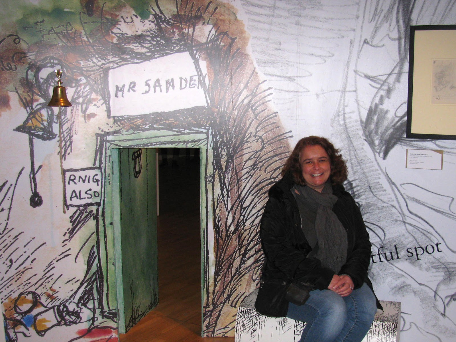
I absolutely loved the exhibition. It was good to see so many of the original drawings which brought back memories of all the Pooh stories, and it was lovely to hear people of all ages chatting, laughing and remembering their favourite books. A replica of Posingford bridge, the bridge on which Milne and his son first played the game Poohsticks, stands in the centre of the exhibition, while trees from Ashdown Forest and Winnie-the-Pooh quotes adorn the walls. Small visitors can climb a narrow flight of steps leading to a slide, and enter Owl’s tiny door with the brass bell labelled "RNIG ALSO".
The exhibition was designed by RFK Architects and the theatre designer Tom Piper. Piper created the installation of thousands of ceramic poppies made by the artist Paul Cummins, which filled the moat of the Tower of London to mark the centenary of the outbreak of the first world war. It left me with a warm fuzzy glow of nostalgia. Even with all the snow on the ground outside.
California Globetrotter
Budget Travelers Sandbox
Sunday Snap
Sundays In My City

Tuesday, 15 December 2015

The Itri Ruins

I have often been asked over the years why I do so much running around with the kids. Why do I use each school holiday to take them to places of interest, museums and on hikes? Why not just stay home and relax? Well, apart from the fact that I learnt from my Mum that all the running around is only a good thing and is eventually acknowledged as worthwhile, this Chanukah break taught me that the window of opportunity is only short. The kids have gone back to school today after almost a week at home and we have done very little this holiday. My eldest, now in his mid-teens, had homework and revision to do. The youngest came out with us one day, but turned his nose up when I suggested a biking trip to Hurvat Itri, also known as the Itri ruins, because apparently we are too slow! Mister Handmade in Israel and I went anyway. We probably were quite slow, but we had a lovely time!
We hired bikes from TrailHead in Moshav Tzafririm, near Bet Shemesh and, acknowledging that we are indeed beginners and yes, pretty slow, we looked at a map of the area and chose an easy route to the Itri ruins and back. It was perfect.
The Itri ruins are the remains of a Second Temple village which was inhabited by Jews for about 800 years. The site is located within the Adulam Park, in the Judean Hills, and derives its name from the ancient Jewish village of Kfar Atra. The Judean Hills were first settled by the Israelite tribe of Judah during the 12th century B.C.E., and then became densely populated by the Jewish people between the 1st century B.C.E. to the 1st century C.E. The village of Atra was a rural Jewish settlement and was at its largest just before it was destroyed by the Romans in 69 C.E. The Jewish people returned and rebuilt their village but then came a second revolt, also known as the Bar Kochba Revolt, which lasted from 132-135 C.E. In the end the Jewish population was beaten and their villages and towns were destroyed.
The Itri ruins, located on a hilltop, were excavated in 2000-2001 by the Israeli Antiquities Authority. The site was recognized as Kfar Atra when an ostracon was found with the inscription 'Atra'. This was probably used as a sort of agricultural receipt. Pottery and coins from the time period of the big rebellion were also found at the site, as well as earthenware candles with Jewish designs and much more. The ruins include embossed burial caves, mikvaot or Jewish ritual baths, a large public building which may have functioned as a synagogue or as a meeting place, a wine press and an oil press. It has been documented that bone remains of 15 people which were buried together with their belongings were found in these ruins. At least one of them was headless because of a sword swing.
We left our bikes at the bottom of the hill and walked up to the ruins, where we walked around between the rocky walls, and enjoyed the view overlooking the valley and hills. The route to the ruins, all on covered roads, had proved ideal for us. It was relatively easy cycling, winding between some gentle hills and fields, but mainly on the flat. After a packed lunch and a walk around, we returned to the main path and literally whizzed down the hill, back to Moshav Tzafririm. That bit was really fun!
We ended our visit at the nearby Adulam Farm, which we had spotted en route. There we treated ourselves to delicious sachlav (sahlab in Arabic), a thick milk-based drink traditionally made with orchid tubers, which is the quintessential warm winter drink of the region. Sitting in the winter sunshine, we enjoyed our drinks sprinkled with cinnamon, crushed walnuts and dried coconut.
The kids missed out big time!