

Of the three sources of the Jordan River, the Dan River is the largest and most important. It is fed by the snow and rain which fall on Mount Hermon, the tallest mountain in Israel. The water seeps into the mountain, branching off into hundreds of springs by the time it reaches the foot. Together these form the largest karstic spring in the Middle East, with an annual flow rate of 240 million cubic metres of water.
The Tel Dan Reserve is only 481 dunams (about 120 acres), yet it features four vastly different trails, one of which is partially wheelchair-accessible. We chose to follow the "Long trail" which passes along tranquil streams, the river, and through several shady areas. Trees growing along the trail include laurel, Italian buckthorn and Syrian ash. The ash, thanks to the good conditions at Tel Dan, grows as tall as 20 metres.
We passed through a beautiful part of the reserve, aptly named "The Paradise", and visited a water-powered flour mill which worked for 100 years, till 1948. We then rested under a huge, ancient pistachio tree with views to the Israel-Lebanon border, the Hula Valley, the Naphtali Mountains, Mount Hermon, and the Golan Heights.
Tel Dan had many cool and shady woods to explore, but the real treat was the sound of running water throughout. Towards the end of the trail we found the freezing cold wading pool, which was an absolute delight. We dipped our tired feet into the cool waters. It was the perfect way to end our visit.
Tel Dan had many cool and shady woods to explore, but the real treat was the sound of running water throughout. Towards the end of the trail we found the freezing cold wading pool, which was an absolute delight. We dipped our tired feet into the cool waters. It was the perfect way to end our visit.


Arguably the most sensational find at Tel Dan, however, was the discovery of parts of a basalt stone stele making up part of a triumphal inscription in Aramaic, left most probably by Hazael of Aram-Damascus, an important regional figure in the late 9th century BCE. Hazael (or more accurately, the unnamed king) boasts of his victories over the king of Israel and his ally the king of the "House of David", the first time the name David had been found outside of the Bible. It is one of only four known ancient inscriptions interpreted to mention the term "Israel" and is currently on display in the Israel Museum in Jerusalem.
Tel Dan also has recent military history. You can walk in a section of trench used by the Israel Defence Forces (I.D.F.) until the Six Day War in 1967, and see where battles were fought and Syrian villages used to be. It would be quite easy to spend an entire day at Tel Dan and clearly I need to go back, especially to visit Ancient Dan.
Tel Dan also has recent military history. You can walk in a section of trench used by the Israel Defence Forces (I.D.F.) until the Six Day War in 1967, and see where battles were fought and Syrian villages used to be. It would be quite easy to spend an entire day at Tel Dan and clearly I need to go back, especially to visit Ancient Dan.


The boys declared it great fun!


 Heading home, we stopped at Belvoir National Park, or Kokhav HaYarden in Hebrew, below. Located 500 metres above the Jordan Valley on an isolated hill top, it overlooks the winding Jordan River and faces the hills of Gilead in the Kingdom of Jordan. The centrepiece of this national park is its magnificently preserved twelfth century Crusader fortress. The park's spectacular panorama gave the fortress its name – belvoir means "beautiful view". Its Hebrew name, "Star of the Jordan", preserves the name of Kochava, a Jewish village which existed nearby during the Roman and Byzantine periods.


The Crusaders built the fortress in around 1140 during the reign of Fulk d’Anjou. In 1168 the Hospitaller Knights bought the land and made it into one of the most important fortresses in the country. About 50 knights and 450 soldiers lived in Belvoir, along with their families and staff.
The fortress was attacked by Muslim forces in 1180, but its strong fortifications withstood the attack. Belvoir served as a major obstacle to the Muslim goal of invading the Crusader Kingdom of Jerusalem from the east and much time and effort was required by the Muslim forces, headed by Saladin, the Muslim military and political leader, to capture it. Only in 1189, after a year-and-a-half-long siege, and once the entire Crusader Kingdom had fallen, did Belvoir's residents agree to surrender and the fortress came under Muslim control. In 1220 the ruler of Damascus sent his men to destroy Belvoir to prevent its re-annexation by the Crusaders.
In modern times Belvoir became an Arab village, Kawkab al-Hawa, whose inhabitants fled during the 1948 War of Independence. Between 1963 and 1968 the site was cleared by the Israel Department of Antiquities and the National Parks Authority.


The reconstructed fortress is the most complete Crusader fortress in the country and the only one all of whose parts have been excavated. Belvoir consisted of an outer square fortress which enclosed a smaller, inner square fortress. Our walk through the ruins revealed halls, cisterns, towers, courtyards, and a 14-metre-deep moat surrounding the outer fortress. Sculptures by the Israeli artist Yigael Tumarkin, inspired by the fortress, are on display south of Belvoir.
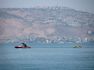
Though we visited on an extremely hot day, and the foundations of the fortress are all that's left, Belvoir is still very impressive. The view itself, of the Jordan River Valley, the Kinneret, the Golan, and the Kingdom of Jordan, made the trip there so worthwhile.


4 comments:
This looks like such an amazing trip. I am surprised to see so much lush green in Israel! It is fascinating what water can feed. The water looks wonderful. I loved tubing when I was young (I probably would still love it). The fish are so cute. The fortress remains are really neat!
such long history in your country! hard to imagine the original tribes living and thriving there. and so much war, too.
yes, tubing is fun. :)
Fascinating and so beautiful - paradise indeed. The thought of pistachio trees is making my mouth water! xx
Israel looks so beautiful too, the sea of Galilee looks so much bigger than I ever imagined. Thank you for sharing these with us. Sarah x
Post a Comment