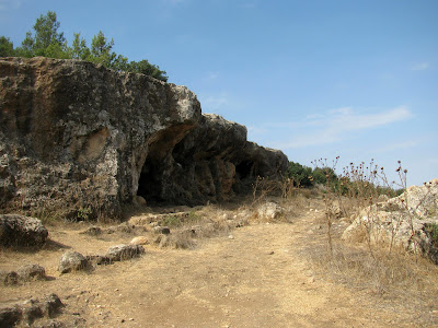
We set off on a particularly beautiful pathway that wound down into the valley, through vineyards and up to some caves, all the time following the signs marked Beit Itab. The caves, above, are apparently sometimes closed for bat nesting but when we passed by they were open. They were interesting to look at and I peeked inside but didn't really fancy climbing in or exploring. The views to the vineyards down below were breathtaking.
The main point of interest on the particular route we had taken were the Beit Itab Ruins, or Hurvat Beit Itab, a further 15-20 minutes walk along the footpath from the caves. It was quite a climb up to the ruins on a hot September day but the observation deck at the top of the hurva (Hebrew for ruins) offered beautiful views of the mountains of Hebron and Jerusalem, the Shfela (lowlands) and the coastal plain. Inside the building, under the roof of the observation deck, a Crusader dining room called the "Refectory" has been preserved.
The observation deck is built on the foundations of a Crusader fortress from the 12th century CE. The fortress is believed to have been established by Johannes Gothman, a Frankish crusader knight known as the owner of the fastest horse in the kingdom. His wife was forced to sell his landholdings after he was taken prisoner by Islamic forces in 1161, in order to raise the money needed for his ransom. The estate was sold to the Church of the Holy Sepulchre.
Gothman's fortress had two storeys, both vaulted, and was built of beautiful hewn stones. The building, which was well fortified, was established on a hill that was 665 metres high and had a view of the entire area. For hundreds of years additional buildings were added and their ruins are scattered around the area.
The Crusaders were defeated at the Battle of Hattin in the Galilee in 1187, ending the First Crusader Kingdom of Jerusalem. An Arab village called Bayt 'Itab was later established around the fortress. Agriculture was its main source of income. The village owned extensive areas of the coastal plain that were planted with grain. During the British Mandate period some of this land was expropriated to make a large, government-owned woodland. A grove of eucalyptus trees was planted by the British army which served as a rest stop for the British soldiers.
During the War of Independence the Arab village of Bayt 'Itab was captured by Israeli forces as part of Operation Ha-Har. Most of the village population fled southwards, towards Bethlehem and Hebron. In 1950 the Israeli village of Nes Harim was established north of the village site. The remains of the Arab village, terraces, an orchard of almond trees, figs, pomegranates and more are scattered around the hill.
From the spring it was a short walk and a climb back up the hill where we had started. The hike had been a particularly nice one because there were a lot of different things to see and do along the way. We had passed vineyards, caves, crusader ruins, a columbarium and a spring, all in a few kilometres walk.
* This post has been shared on Nature Notes, The Good. The Random. The Fun., Wordless Wednesday (on Tuesday), Our World Tuesday, Tuesday's Treasures, Pictorial Tuesday and My Corner of the World.


16 comments:
another fascinating place with so much history. That does look like a great place for a hike with so much to see. #MMBC
How interesting to read about your hike. It looks such a lovely place to explore. The views are amazing x
What another great hike! I miss nature!
What a great place to explore. And some really interesting history. #MMBC
Thank you for the tour, there certainly was plenty to see. I love the views and the ruins look amazing.
Well done on managing another hike before lockdown. It certainly looked worth the effort; what a fascinating and beautiful place. xx
Looks like a great place to take a walk, Lisa. Looks so warm and peaceful here :)
Oh wow! I can't get over the fact that the structure is left over from the Crusades!
Fascinating. I was astounded every time I saw ruins there. It is hard to fathom coming from the US that there is so much history to be found, both out in the open and under the surface of Israel. It is hard for me to imagine how cities could be lost under sand and stone, then resurrected. Amazing.
Thanks for sharing at https://image-in-ing.blogspot.com/2020/12/i-miss-fall-colors.html
Fascinating! :D I especially love the historical links to the Crusades.
un magnifique et passionnant reportage avec de très belles photos. merci.
...ancient takes on a whole new meaning in your area. Take care and stay safe so that you have many more hikes in your future.
Thank you for sharing photos of places to see over there. Sad you had to go back into lock down. Praying we don't have another here...people's businesses are struggling so.
It’s incredible to see so many important cultural sites in a relatively short hike (well, it would be quite long enough for some of us, but still...). I would love to see that preserved crusader dining room (refectory) and just to experience the feeling on the whole hike that you were walking in the footsteps of the important past . ... like you, exploring very far into the caves would be foregone though. Caves are scary even when in a guided tour. I enjoyed this hike and appreciated the research you shared..
I really enjoy posts with some history and this one was great..thank you.. Michelle
Your part of the world is full of such rich history! Thanks for sharing another bit of it and the photos of your hike. I really enjoyed reading your post.
Your link at 'My Corner of the World' this week is an exciting addition! Thanks for joining us!
Post a Comment